


Les Allues- roche de la lune- st Laurent de côte-villarlurin-brides- villarnard-hauteville

XavierFaidix
User
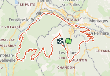

Length
35 km

Max alt
1875 m

Uphill gradient
1610 m
Km-Effort
57 km

Min alt
583 m

Downhill gradient
1619 m
Boucle
Yes
Creation date :
2021-08-12 06:41:02.864
Updated on :
2021-08-12 20:09:02.807
4h00
Difficulty : Difficult

FREE GPS app for hiking
 SityTrail
IGN / Geographical institutes
SityTrail Plus
The world is yours!
About
Trail Mountain bike of 35 km to be discovered at Auvergne-Rhône-Alpes, Savoy, Les Allues. This trail is proposed by XavierFaidix.
Description
parcours VAE
Positioning
Country:
France
Region :
Auvergne-Rhône-Alpes
Department/Province :
Savoy
Municipality :
Les Allues
Location:
Unknown
Start:(Dec)
Start:(UTM)
308556 ; 5034143 (32T) N.
Comments